
So far, 12 Shelter Islanders have submitted applications for Plus One ADU program grants. That’s more than in other towns, Community Housing Board Chair Liz Hanley reported Wednesday.
In partnership with the Community Development Corporation of Long Island (CDCLI), the CHB is locally coordinating this state program. Homeowners can apply for up to $125K in grants to construct a new ADU or bring a unit up to code.
Hanley said the CDCLI extended the deadline for the initial funding round to August 10 to enable applicants to complete their paperwork. The partners aimed to have four grants approved by September. “So, we’re feeling pretty confident,” Hanley said.
The interest level bodes well for the program’s future, she told the CHB. After it authorizes the first grants, CDCLI will launch another funding round. The state has allocated $2M to the Shelter Island program, with more possible based on demand.
CDCLI oversees construction
Once grants are approved, CDCLI oversees all aspects of the construction process from contractor bidding and selection, compliance with standards, general construction oversight and coordination between property owners and contractors, preparation of payment requests and other essential activities to ensure efficient construction.
Haney said CDCLI is planning an August 10 webinar for local contractors to explain how to work within program parameters.
Find additional details about the program on the CHB page of the Town website.
CHF revenues coming in
The 0.5 percent real transfer that voters approved in November has begun to create revenues for the Community Housing Fund, Hanley said.
The tax went into effect in April, with payouts monthly. In May, the Town received $47,425 for the CHF; in June, the amount was $19,625.
The revenue stream will fluctuate month-to-month based on property sales, and whether exemptions applied. The current total is $67,050.
At Wednesday’s meeting, CHB members agreed to place the money in a high interest earning account. Next, the Town’s budget clerk, Shelby Mundy, will set up the account, and the Town Board will adopt a resolution authorizing its creation.
10 is a compelling number
CHB members continue to work on developing plans for affordable housing units on Town-owned parcels. Hanley reminded members that projects of at least 10 units may qualify for county funding. But they don’t have to all be in the same location.
By bundling development across mulitiple sites, the CHB hopes to attract a developer/manager willing to build at least 10 units.
“Until we were on the County funding call, I didn’t realize how compelling 10 as a number was,” Hanley said. “At $250,000 per unit, I feel very motivated to figure out 10.”
Community Housing on Town-owned sites
She said she expects the Suffolk County Department of Health Services to approve up to six units at 12 South Ferry Road. That’s the site of the old Town Highway Barn. A freshwater wetlands occupies a portion. The Town will relocate a police impound facility.
The CHB had hoped to fit eight units there, and Hanley said, “Obviously that’s under what we’re like looking to do and it definitely affects the economics of the situation.”
Some of the four-acre site provides overflow parking for the neighboring Shelter Island Historical Society. Hanley said she and Supervisor Gerry Siller met with the nonprofit’s leadership to talk about possible future impact if public water becomes available, a factor that might enable additional housing.
The CHB is also eyeing the Town-owned parcel at 69 North Ferry Road for housing. CHB members would like to consider the Town-owned site at 16 Manwaring Road. Most recently, the Town has proposed the site for a possible municipal wasterwater treatment system, but formerly earmarked it for housing.
Deputy Supervisor Amber Brach-Williams is a Town Board liaison to the CHB. She said the Town is willing to investigate both options for the Manwaring Road site, reserving the final choice for a later date.
“We know what the goal is,” she said. “We just have to keep moving towards making it all happen.”
Meantime, Siller said he’ll look again at Town-owned parcels that could be suitable for housing.
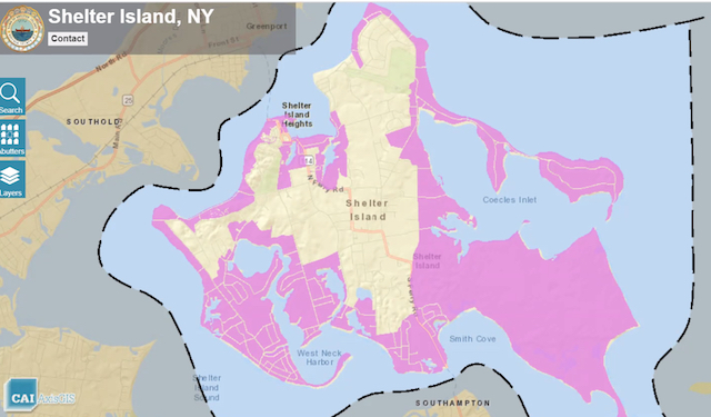
GIS as a tool for housing
CHB member Mark Mobius has been looking at the Town’s GIS portal to see if data already in place can help streamline the search for housing options.
For instance, it may help the CHB identify parcels eligible for the Plus One ADU grants, which aren’t limited to affordable housing, and Community Housing Licenses, which are restricted to income-eligible tenants.
GIS stands for “geographic information systems” which consist of integrated computer hardware and software. A GIS, can store, manage, analyze, edit, output, and visualize geographic data. These systems have been widely adopted to help communities understand the current state of land use and plan for the future.
Town Code, for instance, bans ADUs in the Near Shore Overlay (NSO), which is the Island’s largest zoning district. So using GIS, Mobius said, it’s easy to see where ADUs aren’t allowed.
The CHB could gather GIS data about eligible parcels and develop a mailing list to pitch the program to owners. Mobius asked the other members to think about other criteria, like lot size, that he might use to refine the list.
A previous CHB discussion focused on the difficulty of fitting in affordable housing without the NSO. Read our coverage in this Gazette post.
Visit GIS portals
You can visit the Shelter Island GIS portal here. You can look at data associated with any single lot by clicking on the parcel and following prompts to review available information. Or you can interact with the program to show broader areas — like flood zones or zoning districts.
On the Suffolk County GIS Viewer you can also see aerial photos dating back to 1962, which help to visualize development over time.
There are several statewide GIS programs; this one shows DEC data like well locations, and water allocation and sewer permits. You’ll have to click through checkboxes to select the details you’d like to see and then expand the map to show per parcel data.
