Preparations are underway for a pending Nor’easter from Friday into Saturday, but the National Weather Service says it’s too soon to predict local effects.
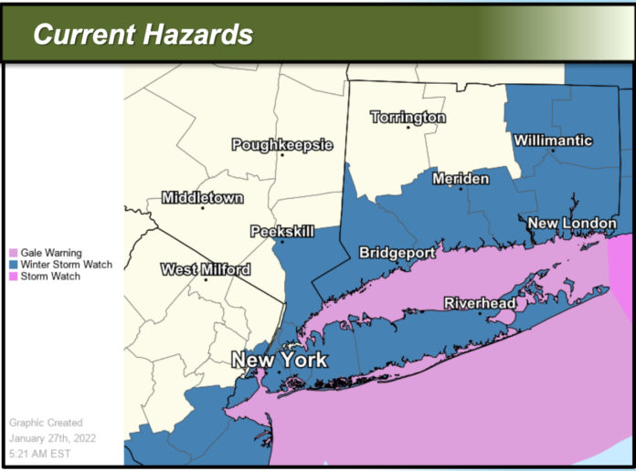
“There is potential for a storm system to bring heavy snowfall and high winds, particularly to eastern portions of the area Friday night into Saturday night,” the NWS said in a regional bulletin issued around 6 AM.
“There is still an unusual amount of uncertainty in snow amounts with this storm two days out,” the NWS said. “Significant changes are possible.”
This isn’t a storm that you can see on the radar headed our way. Instead, atmospheric conditions are right for such a storm, leaving forecasters reliant on modeling to figure out its likely track.
Currently, a Winter Storm Watch and Gale Warning are in effect for Friday night through Saturday night, with expected winds of 30 to 40 miles per hour, with even higher gusts. High winds could kick up ocean waves of 10 to 15 feet and on the Long Island Sound, 4 to 6 feet.
The magnitude of possible coastal flooding will depend on the track and strength of low pressure, the NWS says. But flooding of 1 to 2 feet above average high tide is possible on the East End.
What about snow?
Possible snow totals range from a 10 percent chance of 4 inches of snow at the low end to a 10 percent chance of 20 inches of snow at the high end.
Eastern storm track scenarios would result in light snow accumulations of less than 6 inches on eastern Long Island. If the storm develops on a western track, we’d likely see higher snowfall.
You can see the NWS bulletin by following this link.
If necessary, the Town of Shelter Island will declare a state of emergency, meaning people should stay off roadways to allow for plowing and emergency service access.
Typically, in events with advance warning, PSEG stations a crew on Shelter Island to handle power outages and other electric utility hazards.


