
Henri, now a tropical storm, is passing east of us today, slipping between Montauk Point and Block Island around 11 AM Sunday and heading for landfall in mainland Rhode Island, forecasters say.
The storm is forecast to bring maximum sustained winds of up to 60 mph (95 km/h) with higher gusts, the National Weather Service says. Here on Shelter Island, emergency managers say they anticipate wind speeds of up to 39 mph with some higher gusts around 50 mph.
Tropical storm conditions are already present on the East End, and earlier today, heavy bands of rainfall left water pooled on surfaces.
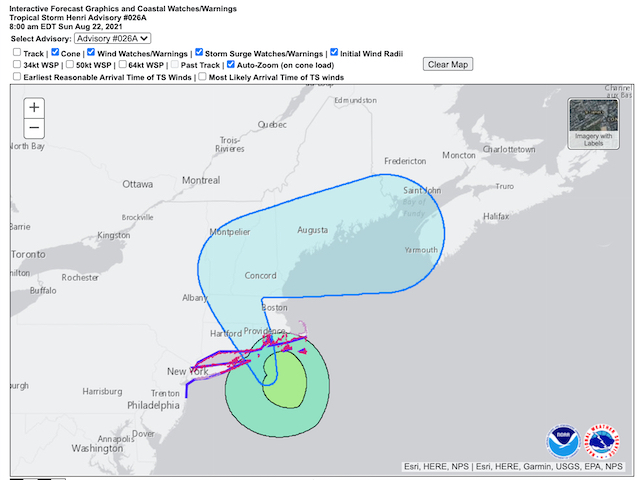
The NWS National Hurricane Center has issued a Tropical Storm Warning with a storm surge possible of 3 to 5 feet, which could be exacerbated by the timing of the high tides made even higher by the full moon.
The storm is expected to produce rainfall amounts of 3 to 6 inches, with areas of up to 10 inches possible.
PSEG Long Island says East End customers should be ready for power outages, some possibly lasting seven to 10 days. PSEG will have personnel and equipment on Shelter Island ready to begin repairs once the weather permits, the Town’s emergency management team says.
The Town of Shelter Island declared a state of emergency and closed roads through 6 AM on Monday (neighboring towns took similar actions). Shelter Island Supervisor Gerry Siller noted that ferry service will also be impacted. The North Ferry was running two boats this morning; the South Ferry, one boat.
Siller asked residents of Ram Island to comply with a voluntary evacuation, saying flooding on causeways may leave Little and Big Ram inaccessible to emergency vehicles.
That order may be rescinded later today, if weather conditions permit.
Governor Andrew M. Cuomo also declared a state of emergency and activated National Guard troops to assist with hurricane preparations, emergency management and cleanup in affected areas, including Suffolk County.
We will post updates from the National Hurricane Center in Miami as they become available.
Bulletin as of 11 AM Sunday
Tropical Storm Henri Intermediate Advisory Number 27
- CENTER OF HENRI PASSING CLOSE TO BLOCK ISLAND AS THE STORM HEADS FOR SOUTHERN NEW ENGLAND
- A DANGEROUS STORM SURGE, HURRICANE CONDITIONS, AND A FLOODING RAINFALL EXPECTED IN PORTIONS OF THE NORTHEAST UNITED STATES
Summary as of 8 AM Sunday
- LOCATION…40.1N 71.3W
- ABOUT 40 MI (65KM) SSE OF MONTAUK POINT, NEW YORK
- ABOUT 75 MI (190KM) S OF PROVIDENCE, RHODE ISLAND
- MAXIMUM SUSTAINED WINDS…70 MPH/110 KM/H
- PRESENT MOVEMENT…NNW OR 345 DEGREES AT 16 MPH (26 KM/H)
- MINIMUM CENTRAL PRESSURE…986 MB…29.12 INCHES
Changes in Watches and Warnings
The Storm Surge Watch has been discontinued from East Rockawy Inlet to west of Mastic Beach and from north of Chatham, MA to Sagamore beach, including Cape Cod Bay.
The Tropical Storm Warning from East Rockaway Inlet to Manasquan Inlet, NJ has been discontinued.
SUMMARY OF WATCHES AND WARNINGS IN EFFECT
A Storm Surge Warning is in effect for:
- South shore of Long Island from Mastic Beach to Montauk Point
- North shore of Long Island from Montauk Point to Flushing
- Flushing, NY to Chatham MA
- Nantucket, Martha’s Vineyard, and Block Island
A Tropical Storm Warning is in effect for:
- East Rockaway Inlet to Chatham, MA, including Long Island
- Block Island, RI, and Nantucket and Martha’s Vineyard, MA
A Storm Surge Warning means there is a danger of life-threatening inundation, from rising water moving inland from the coastline during the next 36 hours in the indicated locations. This is a life-threatening situation. Persons located within these areas should take all necessary actions to protect life and property from rising water and the potential for other dangerous conditions. Promptly follow evacuation and other instructions from local officials.
A Hurricane Warning means that hurricane conditions are expected somewhere within the warning area. A warning is typically issued 36 hours before the anticipated first occurrence of tropical-storm-force winds, conditions that make outside preparations difficult or dangerous. Preparations to protect life and property should be rushed to completion.
A Tropical Storm Warning means that tropical storm conditions are expected somewhere within the warning area within 36 hours.
A Storm Surge Watch means there is a possibility of life-threatening inundation, from rising water moving inland from the coastline, in the indicated locations during the next 48 hours.
A Hurricane Watch means that hurricane conditions are possible within the watch area. A watch is typically issued 48 hours before the anticipated first occurrence of tropical-storm force winds, conditions that make outside preparations difficult or dangerous
Discussions and outlook
At 11 AM EDT (1500 UTC), the center of Tropical Storm Henri was located by reconnaissance aircraft and NOAA Doppler weather radars near latitude 41.1 North, longitude 71.6 West. Henri is moving toward the north-northwest near 12 mph (19 km/h). A north-northwestward motion with a decrease in forward speed is expected this afternoon.
The center of Henri is currently passing near Block Island and on the forecast track, Henri is expected to make landfall in Rhode Island by early afternoon. Henri is forecast to slow down and possibly stall near the Connecticut/New York border tonight, followed by an east-northeastward motion across northern Connecticut and southern Massachusetts on Monday.
Data from the aircraft, Doppler radars, and surface observation indicate that maximum sustained winds have decreased to 60 mph (95 km/h) with higher gusts. Little change in strength is expected until landfall occurs, followed by rapid weakening after Henri moves inland over southern New England.
Tropical-storm-force winds extend outward up to 125 miles (205 km). A Weatherflow station on Block Island, RI, recently reported a sustained wind of 52 mph (84km/h) and a gust to 65 mph (105kh/h). Another Weatherflow station near Point Judith, RI recently measured a sustained wind of 51 mph (82 km/h) and a gust to 57 mph (92 km/h), while an amateur radio operator in Westport, MA recently reported a sustained wind of 41 mph (66 kh/h) and a gust to 62 mph (100 km/h).
The latest minimum central pressure estimated from Air Force Reserve reconnaissance aircraft data is 987 mb (29.15 inches).
Hazards affecting land
Storm surge: The combination of a dangerous storm surge and the tide will cause normally dry areas near the coast to be flooded by rising waters moving inland from the shoreline. The water could reach the following heights above ground somewhere in the indicated areas if the peak surge occurs at the time of high tide:
- Flushing, NY to Chatham, MA including Narragansett Bay, Buzzards Bay, Vineyard Sound, Nantucket Sound, 3 to 5 feet
- North shore of Long Island, from Flushing to Montauk Point, including the Long Island Sound, 3 to 5 feet
- South shore of Long Island, from Mastic Beach to Montauk Point, 3 to 5 feet
- Chatham, MA to Sagamore Beach, MA, including Cape Cod Bay, 2 to 4 feet
- South shore of Long Island from East Rockaway Inlet to Mastic Beach, 2 to 4 feet
- Cape May, NJ to East Rockaway Inlet, NY, 1 to 3 feet
The deepest water will occur along the immediate coast in areas of onshore winds, where the surge will be accompanied by large and dangerous waves. Surge-related flooding depends on the relative timing of the surge and the tidal cycle, and can vary greatly over short distances. For information specific to your area, please see products issued by your local National Weather Service forecast office.
Wind: Hurricane conditions are expected in the Hurricane Warning area late Saturday night or on Sunday, with tropical storm conditions possible by Saturday night. Hurricane conditions are possible in the Hurricane Watch area late Saturday night or on Sunday, with tropical conditions possible by late Saturday night. Tropical storm conditions are possible within the tropical storm watch area late Saturday night and Sunday.
Rainfall: Henri may produce rainfall amounts of 3 to 6 inches over Long Island, New England, southeast New York and southern New England Sunday into Monday, with isolated maximum totals near 10 inches. Heavy rainfall from Henri could result in considerable flash, urban and small stream flooding along with the potential for widespread minor and isolated moderate river flooding.
Tornadoes: A tornado or two may occur Sunday over southern New England.
Surf: Swells generated by Henri should continue to affect Bermuda during the next day or so. Swells are expected to increase across much of the East Coast of the U.S. and Atlantic Canada today and into the weekend. These swells could cause life-threatening surf and rip current conditions. Please consult products from your local weather office.
Satellite image courtesy of NESDIS Satellite Services Division (NOAA).


